Sunny day with temps near 70 again today!
I get an early start this morning - out the door by 7:15am. Just trying to get to the trail head before things get crowded and they will get crowded I past by the parking lots in the afternoon yesterday.
My plan is to hike up to Hickman Bridge and then continue up to the Rim Overlook (and perhaps Navaho Knobs). I've been to all 3 places about 8 years ago on a Guided group trip. And yes, I liked them enough to go back (just took me 8 years).
Hickman Bridge is a rock bridge with a span of 133 ft across.
All 3 hikes share the same trail head and the same trail at least for the first 0.2 mile. Hickman Bridge splits off to the left and the other 2 continue on. Hickman Bridge is 1.8 miles (400 ft elevation gain). The Rim Overlook is 4.6 miles (1110 ft) and Navaho Knobs is 9.4 miles (1620 ft).
When I arrive at the trail head (just off Hwy 24), yea, there are only 2 other cars there!! Great chance of having the natural bridge to myself!
The trail starts next to a creek just for 50-100 ft before it heads up a big rock formation.
Quite a few rock steps and otherwise rocky trail until it flattens. After the climb, I get my first views of Capitol Dome.
Finally, I reach the point where Hickman Bridge heads left and I continue to the bridge. Lots of birds singing and flitting a bout this morning and a few chipmunks and squirrels.
Lovely views along the way.
It not much further when I reach the Bridge loop. Trying to control traffic, traffic down the trail is supposed to be one way -- I'm heading counter-clockwise. Soon I come to what appears to be a dead-end when I look up and I'm standing near the bridge.
Time to investigate.
Well it's time to go and I'm a bit embarrassed because I didn't look at the map very well and I can't find the other part of the "loop trail" so I just head back the way I've came. Oops!
No worries, I only saw 3 people on my way back to the trail intersection. Time to head up to the Rim Overlook.
Soon I'm looking down at Hickman Bridge - different perspective.
Continuing on
I soon see "the Face" -- I think the overlook is near there.
Not quite, I just past the "Face"
and no overlook - still climbing.
Finally, I reach the Overlook - looking down onto the Visitor's Center, the town of Fruita and the Waterpocket Fold (i.e., the geologic land formation that makes up the Capitol Reef area).
I find a bit of shade under a Juniper to rest and get out of the sun for a bit. Well, my mind really wants to go the 2.2 miles to Navajo Knobs but the energy level is just not there today, so I start heading down.
Many folks heading up now.
Finally, a Globeflower that's blooming!
I make it back down to a full parking lot and many, many cars parked along the road. Time to leave this craziness!
Well, since all the trails will be crowded now, I decide to head west about 30 miles to Koosharem Canyon. It's a great butterfly spot in the summer. But sitting at 7000 ft I'm just not sure if anything will be flying yet. But I have the time so off I go.
Along the way, I see some animals that I missed yesterday -- hundreds of ewes and little lambs! And of course, there are cows (with babies) and horses.
I reach the canyon road and start up the gravel path. I see a bunch of Clouded Sulphurs and that's all.
I decide to head about a mile farther west to the Koosharem Reservoir to see if there are any water birds around.
All I see are a couple of Coots but the view ain't bad.
Time to head back. Great Day!
Friday, May 11, 2018
May 4 - Lower Calf Creek (and Capitol Reef)
Decide to head down to Capitol Reef for my long week-end. Drove down most of the way (to Richfield) last night. Had plans for a couple of butterfly stops near Provo but clouds from Thursday's storms were still hanging around the base of the mountains - not good for butterflying - but sunny everywhere else. Oh well!
It was a cold night - Richfield sits at 5300 ft and this morning it's 37 degrees when I head out around 6:30 am. Brrrrr! As I drive east, I pass many cows including some that are shrouded by an eerie fog due to the cold. Lots of little calves with those cows.
Lots of wild animals out and a bout this morning.
I'm not far out of Richfield when I have to slow down as 5 deer calmly cross the road ahead of me. A few miles down the road, I see a lone deer in the distance.
The road climbs on a curvy road up to a pass at 7300 ft. No snow but it's 29 degrees and the farmers that have irrigation running have icy vegetation under the spraying water.
As I near the turn to the town of Koosharem, I see a large brown hawk (or maybe a Golden Eagle) on the side of the road eating something, His wings are up protecting his goodies from the crow that sits in wait. Wish I could stop but I'm on a 65mph road with no easement so I just cruise by.
And just outside of Koosharem, I slam on my brakes to avoid hitting 2 deer that decide to cross the road. (There were actually 3 deer, the one had previously crossed.)
Can't forget the smaller bison herd near Torrey (I think). Pretty sure it's not a wild herd - farmed.
In about an hour I arrive in Torrey -- the gateway to Capitol Reef. But my plan is to head down US 12 past Boulder, over the Hogsback to Lower Calf Creek. I was there last year actually almost 1 year to the day (May 5).
US 12 is a curvy scenic road that climbs over Boulder Mt. I pass the viewpoints as they are facing east into the rising sun. But do enjoy seeing the snow that appears as I pass the 8000ft mark. It's only in spots and it's probably less than a few inches but as I get closer to the pass at 9600 ft, the ground is covered. Very pretty! (I do see a lone deer on the way up.)
As I near that pass, I have to stop again. Not for deer but for a lone turkey crossing the road. Actually makes me smile.
Soon I arrive in Boulder and simply pass thru in a blink of an eye. On my way towards the Hogsback, I see what I think are 2 crows in the middle of the road eating some roadkill but as I approach, up flies one crow and one Turkey Vulture!
Not a bad morning - deer, hawk/eagle, turkey and turkey vulture!!
I arrive on the Hogsback, narrow band of curvy road crossing over white slickrock ridge. The views are amazing but, at least for me, it's a white-knuckle drive. On slip in attention and it's a long way down.
But the Lower Calf Creek trail is somewhere down there!
After I cross, I arrive at the Lower Calf creek parking. I left early because last year I arrived at 9:30 and I got one of the last 2 official parking spots. I arrive just before 9am today and there are plenty of spots - yea!
It's sunny and in the mid-50s - perfect day!
As I start up the 3 mile one-way trail, the first thing I notice is the lack of flowers. Last year, there was so much blooming but today, it's pretty sparse. I wonder if there will be any butterflies.
There are some flowers blooming but most of the blooming are shrubs & trees
and the gorgeous Claret Catcus!
Lots of birds flitting around and singing wonderful songs all the way to the falls. I see Spotted Towhee,
and many others which I can't ID.
The squirrels and chipmunks are also running around.
So when the butterflies aren't flying and there aren't many flowers to stop for, got to turn to moths!
And hanging inch worms :)
But the scenery is awesome!
Well the trail has 14 interpretative spots. At #9 I finally see my first butterfly - Two Tailed Swallowtail!!! That's gives me hope that on my way back (warmer, sun higher) I might find some more!
The last mile or so of the trail is mostly shady and follows the creek. Lots of horsetail in spots. In other spots, Solomon's Seal. Soon I get my first glimpse of the falls!
When I arrive, there are two people about to leave and then the Falls is all mine!! And I enjoy!
As I'm about to leave, two people are arriving. As I proceed down the trail, the procession of people is incredible! I'm so happy I got here when I did!
But despite having to step off the trail a LOT, the walk back yields butterflies!!! Not far from the falls, I see 2 Duskywings! I'm not sure which species though.
I see a couple more a little further down the trail. They seem to like the Dandelions this morning.
Continuing on, I get glimpse of a Field Crescent, another Two-tail Swallowtail and a Painted Lady.
The lizards are now out!
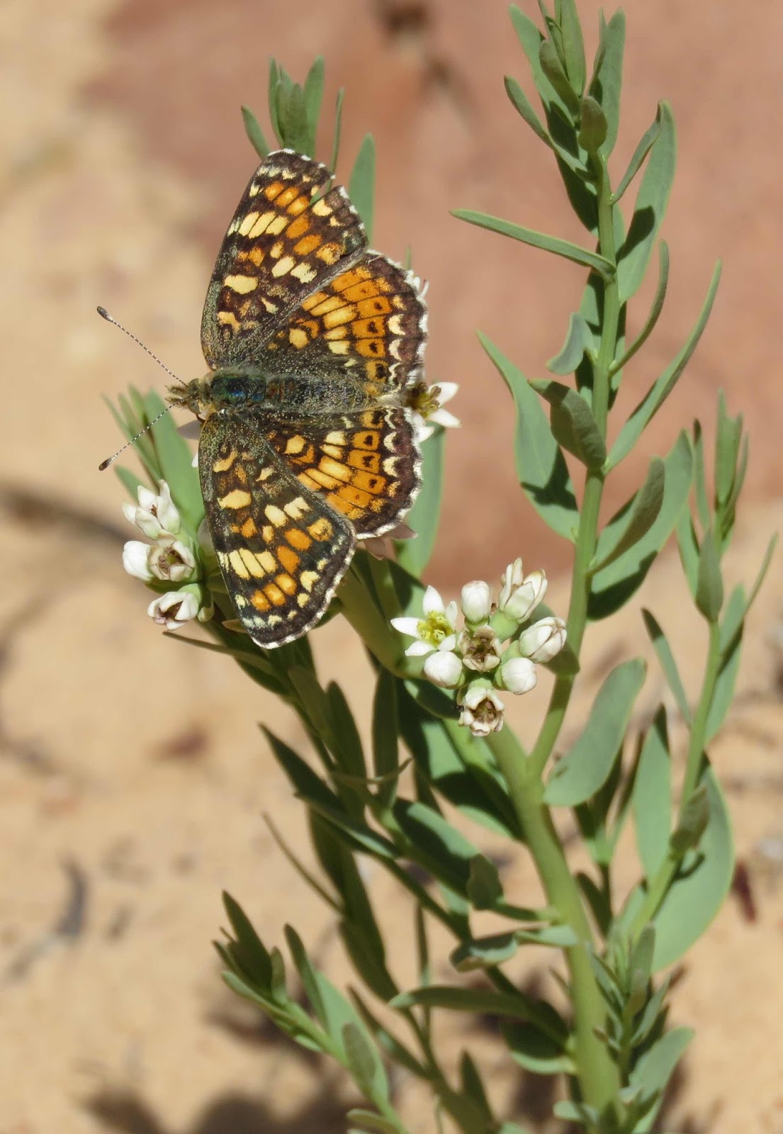
Still further down the trail, I catch up with a Field Crescent
and a Variable "Anicia" Checkerspot. (Saw many of these last year; only one today.)
(The butterflies did come out!!)
I complete the trail and quickly escape the madness heading back over the Hogsback for lunch at the Burr Trail Grill (awesome place) in Boulder. Then I head back to Torrey.
It's only 2 pm when I get back to Torrey, so I decide to drive through Capitol Reef making tourist stops
and then out to Notom Road which is on the east side of the Monument. I head south down the road to the Burro Wash - I just want a photo of the snowy LaSal Mountains.
Then I head back to Torrey to end my day.
Well not quite. After dinner, I decide to go back into the park for a peek into the Goosenecks
And a 2/3 mile walk to Sunset Point.
Can't miss the cool divots and pockets in the small rocks from years of erosion - beautiful!
Now that's the end of my wonderful day!
It was a cold night - Richfield sits at 5300 ft and this morning it's 37 degrees when I head out around 6:30 am. Brrrrr! As I drive east, I pass many cows including some that are shrouded by an eerie fog due to the cold. Lots of little calves with those cows.
Lots of wild animals out and a bout this morning.
I'm not far out of Richfield when I have to slow down as 5 deer calmly cross the road ahead of me. A few miles down the road, I see a lone deer in the distance.
The road climbs on a curvy road up to a pass at 7300 ft. No snow but it's 29 degrees and the farmers that have irrigation running have icy vegetation under the spraying water.
As I near the turn to the town of Koosharem, I see a large brown hawk (or maybe a Golden Eagle) on the side of the road eating something, His wings are up protecting his goodies from the crow that sits in wait. Wish I could stop but I'm on a 65mph road with no easement so I just cruise by.
And just outside of Koosharem, I slam on my brakes to avoid hitting 2 deer that decide to cross the road. (There were actually 3 deer, the one had previously crossed.)
Can't forget the smaller bison herd near Torrey (I think). Pretty sure it's not a wild herd - farmed.
In about an hour I arrive in Torrey -- the gateway to Capitol Reef. But my plan is to head down US 12 past Boulder, over the Hogsback to Lower Calf Creek. I was there last year actually almost 1 year to the day (May 5).
US 12 is a curvy scenic road that climbs over Boulder Mt. I pass the viewpoints as they are facing east into the rising sun. But do enjoy seeing the snow that appears as I pass the 8000ft mark. It's only in spots and it's probably less than a few inches but as I get closer to the pass at 9600 ft, the ground is covered. Very pretty! (I do see a lone deer on the way up.)
As I near that pass, I have to stop again. Not for deer but for a lone turkey crossing the road. Actually makes me smile.
Soon I arrive in Boulder and simply pass thru in a blink of an eye. On my way towards the Hogsback, I see what I think are 2 crows in the middle of the road eating some roadkill but as I approach, up flies one crow and one Turkey Vulture!
Not a bad morning - deer, hawk/eagle, turkey and turkey vulture!!
I arrive on the Hogsback, narrow band of curvy road crossing over white slickrock ridge. The views are amazing but, at least for me, it's a white-knuckle drive. On slip in attention and it's a long way down.
But the Lower Calf Creek trail is somewhere down there!
After I cross, I arrive at the Lower Calf creek parking. I left early because last year I arrived at 9:30 and I got one of the last 2 official parking spots. I arrive just before 9am today and there are plenty of spots - yea!
It's sunny and in the mid-50s - perfect day!
As I start up the 3 mile one-way trail, the first thing I notice is the lack of flowers. Last year, there was so much blooming but today, it's pretty sparse. I wonder if there will be any butterflies.
There are some flowers blooming but most of the blooming are shrubs & trees
and the gorgeous Claret Catcus!
Lots of birds flitting around and singing wonderful songs all the way to the falls. I see Spotted Towhee,
and many others which I can't ID.
The squirrels and chipmunks are also running around.
So when the butterflies aren't flying and there aren't many flowers to stop for, got to turn to moths!
And hanging inch worms :)
But the scenery is awesome!
Well the trail has 14 interpretative spots. At #9 I finally see my first butterfly - Two Tailed Swallowtail!!! That's gives me hope that on my way back (warmer, sun higher) I might find some more!
The last mile or so of the trail is mostly shady and follows the creek. Lots of horsetail in spots. In other spots, Solomon's Seal. Soon I get my first glimpse of the falls!
When I arrive, there are two people about to leave and then the Falls is all mine!! And I enjoy!
As I'm about to leave, two people are arriving. As I proceed down the trail, the procession of people is incredible! I'm so happy I got here when I did!
But despite having to step off the trail a LOT, the walk back yields butterflies!!! Not far from the falls, I see 2 Duskywings! I'm not sure which species though.
I see a couple more a little further down the trail. They seem to like the Dandelions this morning.
Continuing on, I get glimpse of a Field Crescent, another Two-tail Swallowtail and a Painted Lady.
The lizards are now out!
Still further down the trail, I catch up with a Field Crescent
and a Variable "Anicia" Checkerspot. (Saw many of these last year; only one today.)
(The butterflies did come out!!)
I complete the trail and quickly escape the madness heading back over the Hogsback for lunch at the Burr Trail Grill (awesome place) in Boulder. Then I head back to Torrey.
It's only 2 pm when I get back to Torrey, so I decide to drive through Capitol Reef making tourist stops
and then out to Notom Road which is on the east side of the Monument. I head south down the road to the Burro Wash - I just want a photo of the snowy LaSal Mountains.
Then I head back to Torrey to end my day.
Well not quite. After dinner, I decide to go back into the park for a peek into the Goosenecks
And a 2/3 mile walk to Sunset Point.
Can't miss the cool divots and pockets in the small rocks from years of erosion - beautiful!
Now that's the end of my wonderful day!
Tuesday, May 8, 2018
May 7 - On the hunt for Desert Marbles (Johnson Pass)
Took a vacation day today for a chance at seeing the Desert Marble butterfly for the first time. I have seen the larger Large Marble many times since I've been in Utah, so it's time to add a new butterfly to my Life List.
I've been told to head either to Cedar Fort or Johnson Pass between 5/1 - 5/10. Since I was at Cedar Fort on 4/26 I decided to go to a new place.
Johnson Pass (`6400 ft) is in the Stansbury Mts. I've actually never been there but they are the western most range from Salt Lake followed by the nearer Oquirrh Mt Range and then the Wasatch Mts to the east. Just like Cedar Fort, it's a Pinyon/Juniper habitat.
This morning is not the perfect butterfly weather as it is overcast (high clouds) with peeks of sun/blue sky but it is warmish at around 70 degrees (80 degree high).
I head west on I-80 around 8:30 am. Only a few miles outside the SLC airport I see what looks like a small herd of Pronghorn but not totally sure. But in about another mile, I confirm that they were Pronghorn because I pass another herd closer to the road. (Hey, I don't need to go to Antelope Island anymore!!)
As I pass the Great Salt Lake State Park, I see quite a few Yellow-headed Blackbirds (Red-winged Blackbirds too).
I exit south at the Tooele exit. I'm in between the Oquirrh and Stansbury mountains and this is all new territory for me. And once out of the city, it's so pretty. Besides the views of the two mountain ranges, there lots of open space filled with cows, horses, farms and sagebrush. (And the lone coyote I see standing in one of the fields.) Love it! (Hey, there's a coyote in that field!)
At Hwy 199 I turn west heading to the Pass. Within 10 miles, the windy road takes me to Johnson Pass. The official lot is on the south side of the road but the coordinates I'm given are on the north side. I park off a dirt road on the north side and it's time to wander.
I'm not out of the car but a few minutes, I see a White flying by. Don't know if it's my butterfly but I assume it is. But I need to keep looking for one that's more cooperative.
As I walk around through the Junipers and sagebrush, there's not many sources of nectar but I do find a few Indian Paintbrush
Puccoon
Balsamroot
Milkvetch, and Parsley but the species that most prevalent are the Forget-me-knots.
I also see a few lizards.
Finally, I see a White land and he's playing nice!
But he doesn't look like what I remember a Desert Marble should look like - he has a thin forewing bar, I remember a wider one. But I have no butterfly book and no cell service so I'm assuming it's a Desert Marble. Yea!
I've walked around the north side of the road enough so I head over to the south side. Definitely more nectar over here with Phlox
and these tiny yellow flowers.
And I get lucky the sun is out (for now anyway).
I see a couple more of those Whites flying. I'm about to give up when I decide to try the SE corner of the gravel parking lot and there flying is a small white butterfly. It's small than the other ones and I know I've seen a Desert Marble. He's flitting a bout but finally stops and I see that wide wing bar!!
While he was nectaring, a larger white butterfly flies in and they swirl a bout before the larger one lands. He's definitely Marble and he sure looks like a Large Marble but the two usually fly in different habitats.
I'm confused but happy. I watch for 10-15 minutes before losing both of them.
Time for a very happy drive home!!
(When I get home, I post my photos to the local Lep group and ask about the larger white butterfly. The reply I receive confirms that they do fly in different habitats -- Large Marble typically deciduous river canyons at higher elevations and Desert Marbles in lower elevations in drier Pinyon/Juniper habitats. But the Large Marbles will sometimes come down to lower elevations to nectar. They even believe that the larger ones are Large Marbles. Very cool!!)
I've been told to head either to Cedar Fort or Johnson Pass between 5/1 - 5/10. Since I was at Cedar Fort on 4/26 I decided to go to a new place.
Johnson Pass (`6400 ft) is in the Stansbury Mts. I've actually never been there but they are the western most range from Salt Lake followed by the nearer Oquirrh Mt Range and then the Wasatch Mts to the east. Just like Cedar Fort, it's a Pinyon/Juniper habitat.
This morning is not the perfect butterfly weather as it is overcast (high clouds) with peeks of sun/blue sky but it is warmish at around 70 degrees (80 degree high).
I head west on I-80 around 8:30 am. Only a few miles outside the SLC airport I see what looks like a small herd of Pronghorn but not totally sure. But in about another mile, I confirm that they were Pronghorn because I pass another herd closer to the road. (Hey, I don't need to go to Antelope Island anymore!!)
As I pass the Great Salt Lake State Park, I see quite a few Yellow-headed Blackbirds (Red-winged Blackbirds too).
I exit south at the Tooele exit. I'm in between the Oquirrh and Stansbury mountains and this is all new territory for me. And once out of the city, it's so pretty. Besides the views of the two mountain ranges, there lots of open space filled with cows, horses, farms and sagebrush. (And the lone coyote I see standing in one of the fields.) Love it! (Hey, there's a coyote in that field!)
At Hwy 199 I turn west heading to the Pass. Within 10 miles, the windy road takes me to Johnson Pass. The official lot is on the south side of the road but the coordinates I'm given are on the north side. I park off a dirt road on the north side and it's time to wander.
I'm not out of the car but a few minutes, I see a White flying by. Don't know if it's my butterfly but I assume it is. But I need to keep looking for one that's more cooperative.
As I walk around through the Junipers and sagebrush, there's not many sources of nectar but I do find a few Indian Paintbrush
Puccoon
Balsamroot
Milkvetch, and Parsley but the species that most prevalent are the Forget-me-knots.
I also see a few lizards.
Finally, I see a White land and he's playing nice!
But he doesn't look like what I remember a Desert Marble should look like - he has a thin forewing bar, I remember a wider one. But I have no butterfly book and no cell service so I'm assuming it's a Desert Marble. Yea!
I've walked around the north side of the road enough so I head over to the south side. Definitely more nectar over here with Phlox
and these tiny yellow flowers.
And I get lucky the sun is out (for now anyway).
I see a couple more of those Whites flying. I'm about to give up when I decide to try the SE corner of the gravel parking lot and there flying is a small white butterfly. It's small than the other ones and I know I've seen a Desert Marble. He's flitting a bout but finally stops and I see that wide wing bar!!
While he was nectaring, a larger white butterfly flies in and they swirl a bout before the larger one lands. He's definitely Marble and he sure looks like a Large Marble but the two usually fly in different habitats.
I'm confused but happy. I watch for 10-15 minutes before losing both of them.
Time for a very happy drive home!!
(When I get home, I post my photos to the local Lep group and ask about the larger white butterfly. The reply I receive confirms that they do fly in different habitats -- Large Marble typically deciduous river canyons at higher elevations and Desert Marbles in lower elevations in drier Pinyon/Juniper habitats. But the Large Marbles will sometimes come down to lower elevations to nectar. They even believe that the larger ones are Large Marbles. Very cool!!)
Subscribe to:
Posts (Atom)